February 17, 2014
Newly released information about the location of military assets on the night of the terrorist attacks in Benghazi in 2012 has been met with a yawn by the mainstream media, but it has caused quite a stir in the conservative press.
Most of the media are following the lead of the Obama administration, arguing that while the outcome in Benghazi was regrettable, it was merely due to mistakes that have since been addressed, and it’s long past time to move on. Any suggestion of this being a scandal, that narrative goes, is the result of Fox News and talk-radio pushing an agenda, combined with thinly disguised racism. We have shown time and again why this is, in fact, a very real and significant scandal and should be seen as such by the media and Congress.
Several congressional and administration reports consider the military response to Benghazi to have been justifiable. “The interagency response was timely and appropriate, but there simply was not enough time for armed U.S. military assets to have made a difference,” concluded the Accountability Review Board (ARB) back in December 2012. “As the only military member of the ARB, I personally reviewed all of the military assets that were in theater and available,” Admiral Michael Mullen, Vice Chair of the ARB, said in an interview in June of last year. This board was largely handpicked by Secretary of State Hillary Clinton to investigate Benghazi, but she was never interviewed by them.
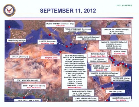
Now, Americans have gotten a glimpse into which naval forces were active on September 11, 2012 and can judge for themselves. A new map has been released by Judicial Watch that details the location of multiple ships in the region. Judicial Watch has done an excellent job in reporting on and analyzing the situation in Benghazi, and their Freedom of Information requests have yielded significant information.
However, the fact that there were many ships in the area does not necessarily mean that they provided the instant military capacity to have affected the outcome. The far-left Mother Jones publication has argued, “This Map Is Not the Benghazi Smoking Gun Conservatives Think It Is.” This is because “Most of the ‘dozens’ of ships were nowhere near Benghazi, and the list includes many vessels that wouldn’t do much good in a rescue situation,” wrote Tim Murphy for MoJo. In this instance, they may have stumbled on the truth.
The Navy noted in a letter to the Freedom of Information Act requester that “ENTERPRISE was approximately 3350 nautical miles from Benghazi. Assuming a 20 knot transit speed and no Suez Canal delays, the transit would take approximately 168 hours or seven days.” And the closest amphibious vessel, IWO JIMA, was “underway in the Gulf of Oman,” wrote Captain B.C. Nickerson for the Navy.
In other words, no naval help was on its way that night; and the best help was too far away to make a difference.
But the real story here is not that there were military assets in the immediate area that weren’t used to rescue the Americans under attack in Benghazi. Rather, it is that this newly released information underscores the fact that there should have been forces on hand and ready to deal with this kind of situation.

No comments:
Post a Comment